

DJI / DRONE PROFILE
DJI Mavic Air 2
Explore the available technical information for this aircraft, including camera capabilities, flight performance and manufacturer-specific specifications.
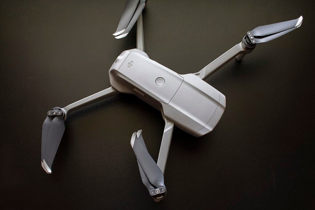
The DJI Mavic Air 2 is a folding camera drone introduced as a step up from the original Mavic Air. It combines a 1/2-inch camera sensor, 48 MP still-photo mode, 4K video recording and a 3-axis mechanical gimbal. Although it is now a legacy model, its camera and flight specifications remain useful reference points when comparing second-hand drones.
Key specifications
- Takeoff weight: 570 g
- Maximum flight time: 34 minutes in DJI’s stated no-wind test
- Maximum horizontal speed: 19 m/s in S mode
- Maximum flight distance: 18.5 km under manufacturer test conditions
- Camera: 1/2-inch CMOS; 12 MP and 48 MP photo modes
- Video: up to 4K at 60 fps
- Gimbal: 3-axis mechanical stabilisation
- Internal storage: 8 GB, plus microSD support
- Satellite positioning: GPS and GLONASS
Camera performance
The Mavic Air 2 camera supports both 12 MP and 48 MP still photographs, with JPEG and DNG RAW formats. It records 4K video at up to 60 frames per second and includes D-Cinelike and Normal colour profiles. The 3-axis gimbal provides mechanical stabilisation for smoother footage. The 48 MP mode is useful for detailed still images in good light, while the 4K/60 fps option gives creators more flexibility for motion and editing.
Flight features and sensing
DJI lists up to 34 minutes of flight time in a no-wind test, but real-world sessions are shorter. The aircraft includes forward and backward vision sensing and downward sensors, with APAS 3.0 assistance. It does not provide left- and right-side obstacle sensing, so sideways flight near trees, buildings or wires requires particular care. OcuSync 2.0 provides the video-transmission link, with maximum distance figures depending on regional radio rules and test conditions.
Who is it for?
The Mavic Air 2 can still interest photographers and hobby pilots who find a well-maintained used kit at a reasonable price. Its 4K/60 fps camera and 3-axis gimbal make it more capable for video than many entry-level older drones. However, buyers should compare it with newer Air and Mini models for image processing, sensing coverage, battery availability, software support and repair options.
Used-buying checklist
- Check battery health, cycle count and physical condition.
- Inspect propellers, motors, arms and landing surfaces.
- Test the camera, gimbal, obstacle sensors and GPS.
- Confirm the remote controller, charging hub and app compatibility.
- Check local registration and operating rules before flying.
This is a specification-based product overview, not a hands-on review. Flight time, speed and transmission distance are manufacturer figures measured under defined conditions.
Official reference: DJI Mavic Air 2 specifications and support.
Drone Specifications
| Brand | DJI |
|---|---|
| Camera | 1/2-inch CMOS; 12 MP / 48 MP photos; 4K video up to 60 fps |
| Maximum Flight Time (minutes) | 34 min (windless test) minutes |
| Maximum Transmission Range (km) | 10 km |
| Weight (g) | 570 g |
| Battery Capacity (mAh) | 3500 mAh |
| Wind Resistance (m/s) | 8 m/s |
| Obstacle Sensing | Forward, backward and downward vision; no lateral sensing |
| Positioning / GPS | GPS + GLONASS |
| Maximum Speed (m/s) | 19 m/s |
Additional Notes
Mavic Air 2: 570 g; dimensions folded 180 × 97 × 84 mm, unfolded 183 × 253 × 77 mm. Max flight distance 18.5 km (not transmission range). Max ascent 4 m/s, descent 3 m/s. Transmission maximum 10 km FCC / 6 km CE under unobstructed conditions. 8 GB internal storage.
Specification source: Official source
Official Price (USD)
No public USD price was verified on the manufacturer’s official store during this check.
For enterprise or discontinued models, contact the manufacturer for a current quotation. We do not substitute third-party seller prices.
Price checked: 2026-11-07


Aircraft & Flight
| Maximum horizontal speed | 19 m/s S mode; 12 m/s N mode; 5 m/s T mode |
|---|
Navigation & Obstacle Sensing
| Supported GNSS systems | GPS + GLONASS |
|---|
Operating Conditions & Dimensions
| Maximum wind resistance | 8.5–10.5 m/s (Level 5) |
|---|
MANUFACTURER DATA
Detailed official specifications
Technical figures below are transcribed from the manufacturer documentation linked with this profile. Test figures are maximum or controlled-condition ratings where stated; actual performance varies by configuration and operating conditions. A field is omitted when the cited source does not publish a reliable value.
| Aircraft — Weight | 570 g |
|---|---|
| Aircraft — Size | Folded:; 180×97×84 mm (Length×Width×Height); Unfolded:; 183×253×77 mm (Length×Width×Height) |
| Aircraft — Diagonal Distance | 302 mm |
| Aircraft — Max Ascent Speed | 4 m/s (S Mode); 4 m/s (N Mode) |
| Aircraft — Max Descent Speed | 3 m/s (S Mode); 3 m/s (N Mode); 5 m/s (S Mode and N Mode during a sharp descent); 3 m/s (all modes at elevations over 4500 m) |
| Aircraft — Max Service Ceiling Above Sea Level | 5000 m |
| Aircraft — Max Flight Time (without wind) | 34 minutes |
| Aircraft — Max Hover Time (without wind) | 33 minutes |
| Aircraft — Max Flight Distance | 18.5 km |
| Aircraft — Max Horizontal Flight Speed | 19 m/s (S Mode); 12 m/s (N Mode); 5 m/s (T Mode) |
| Aircraft — Max Wind Resistance | 8.5-10.5 m/s (Level 5) |
| Aircraft — Max Pitch Angle | 35° (S Mode); 20° (N Mode); 35° (N Mode under strong wind) |
| Aircraft — Max Angular Velocity | 250°/s (S Mode); 250°/s (N Mode) |
| Aircraft — Operating Temperature Range | -10° to 40°C (14° to 104°F) |
| Aircraft — Operating Frequency | 2.400-2.4835 GHz; 5.725-5.850 GHz |
| Aircraft — Transmitter Power (EIRP) | 2.400-2.4835 GHz:; FCC: ≤26 dBm; CE: ≤20 dBm; SRRC: ≤20 dBm; MIC: ≤20 dBm; ; 5.725-5.850 GHz:; FCC: ≤26 dBm; CE: ≤14 dBm; SRRC: ≤26 dBm |
| Aircraft — Hovering Accuracy Range | Vertical:; ±0.1 m (with vision positioning); ±0.5 m (with GPS positioning); ; Horizontal:; ±0.1 m (with vision positioning); ±1.5 m (with GPS positioning) |
| Aircraft — Propellers | Quick release, low noise, folding |
| Aircraft — Satellite Systems | GPS+GLONASS |
| Aircraft — Compass | Single Compass |
| Aircraft — IMU | Single IMU |
| Aircraft — Internal Storage | 8 GB |
| Battery — Capacity | 3500 mAh |
| Battery — Voltage | 11.55 V |
| Battery — Charging Voltage Limit | 13.2 V |
| Battery — Battery Type | LiPo 3S |
| Battery — Energy | 40.42 Wh |
| Battery — Weight | 198 g |
| Battery — Charging Temperature | 5° to 40°C (41° to 104°F) |
| Battery — Max Charging Power | 38 W |
| Camera — Sensor | 1/2" CMOS; Effective Pixels: 12 MP and 48 MP |
| Camera — Lens | FOV: 84°; Equivalent Focal Length: 24 mm ; Aperture: f/2.8; Focus Range: 1 m to ∞ |
| Camera — ISO | Video:; 100-6400; ; Photo (12 MP):; 100-3200 (Auto); 100-6400 (Manual); Photo (48 MP):; 100-1600 (Auto); 100-3200 (Manual) |
| Camera — Max Photo Resolution | 48 MP 8000×6000 pixel |
| Camera — Photo Modes | Single: 12 MP and 48 MP; Burst: 12 MP, 3/5/7 frames; Automatic Exposure Bracketing (AEB): 12MP, 3/5 Frames at 0.7EV Bias; Timed: 12 MP 2/3/5/7/10/15/20/30/60 seconds; SmartPhoto: Scene Recognition, HyperLight, and HDR; HDR Panorama[1]:; Vertical (3×1): 3328×8000 pixels (Width×Height); Wide-angle (3×3): 8000×6144 pixels (Width×Height); 180° Panorama (3×7): 8192×3500 pixels (Width×Height); Sphere (3×8+1): 8192×4096 pixels (Width×Height) |
| Camera — Photo Formats | JPEG/DNG (RAW) |
| Camera — Video Resolution and Frame Rates | 4K Ultra HD: 3840×2160 24/25/30/48/50/60 fps; 2.7K: 2688×1512 24/25/30/48/50/60 fps; FHD: 1920×1080 24/25/30/48/50/60/120/240 fps; 4K Ultra HD HDR: 3840×2160 24/25/30 fps; 2.7K HDR: 2688×1512 24/25/30 fps; FHD HDR: 1920×1080 24/25/30 fps |
| Camera — Color Profiles | D-Cinelike, Normal |
| Camera — Video Formats | MP4/MOV (H.264/MPEG-4 AVC, H.265/HEVC) |
| Camera — Max Bitrate | 120 Mbps |
| Camera — Supported SD Cards | Supports a microSD with capacity of up to 256 GB |
| Camera — Supported File Systems | FAT32 and exFAT |
| Camera — Zoom | Available |
| Gimbal — Stabilization | 3-axis (tilt, roll, pan) |
| Gimbal — Mechanical Range | Tilt: -135° to 45°; Roll: -45° to 45°; Pan: -100° to 100° |
| Gimbal — Controllable Range | Tilt: -90° to 0° (Default); -90° to 24° (Extended) |
| Gimbal — Max Controllable Speed (tilt) | 100°/s |
| Gimbal — Angular Vibration Range | ±0.01° |
| Vision System — Forward | Precision Measurement Range: 0.35-22.0 m; Detection Range: 0.35 to 44 m; Effective Sensing Speed: 12 m/s ; Field of View (FOV):; 71° (horizontal), 56° (vertical) |
| Vision System — Backward | Precision Measurement Range: 0.37-23.6 m; Detection Range: 0.37-47.2 m; Effective Sensing Speed: 12 m/s ; Field of View (FOV):; 57° (horizontal), 44° (vertical) |
| Vision System — Available Downward Sensors | Dual Vision Sensors + Time of Flight Sensors (ToF) |
| Vision System — Downward | ToF Measurement Range: 0.1-8 m; Hovering Range: 0.5-30 m; Vision Sensor Hovering Range: 0.5-60 m |
| Vision System — Left/Right | None |
| Vision System — Downward Auxillary Light | Single LED |
| Safety — Obstacle Avoidance System | Advanced Pilot Assistance Systems (APAS) 3.0 |
| Video Transmission — Transmission System | OcuSync 2.0; 2.4 GHz/5.8 GHz Auto-Switching |
| Video Transmission — Max Transmission Distance | 10 km (FCC), 6 km (CE), 6 km (SRRC), 6 km (MIC) |
| Video Transmission — Live View Quality | 720p@30fps/1080@p30fps |
| Video Transmission — Latency (depending on environmental conditions and mobile device) | 120-130 ms |
| Video Transmission — Video Transmission Encoding format | H.265/H.264 (Auto-switches depending on encoding capabilities of device) |
| Video Transmission — Max Transmission Bitrate | 12 Mbps |
| Video Transmission — Operating Frequency | 2.400-2.4835 GHz; 5.725-5.850 GHz |
| Remote Controller — Remote Controller Transmission System | When used with different aircraft hardware configurations, DJI RC-N1 Remote Controllers will automatically select the corresponding firmware version for updating and support the following transmission technologies enabled by the hardware performance of the linked aircraft models: ; a. DJI Mini 2/ DJI Mavic Air 2: O2; b. DJI Air 2S: O3; c. DJI Mavic 3: O3+ |
| Remote Controller — Supported Mobile Device Connectors | Lightning, Micro USB, USB Type-C |
| Remote Controller — Max. Supported Mobile Device Size | 180×86×10 mm (Height×Width×Thickness) |
| Remote Controller — Operating Temperature | -10° to 40°C (14° to 104°F) |
| Remote Controller — Transmitter Power (EIRP) | 2.400-2.4835 GHz: ; <26 dBm (FCC), <20 dBm (CE/SRRC/MIC) ; 5.725-5.850 GHz: ; <26 dBm (FCC), <23 dBm (SRRC), <14 dBm (CE) |
| Remote Controller — Operating Current/Voltage | 1200 mA@3.6V (Android); 700 mA@ 3.6 V (iOS) |
| Charger — Charging Input | 100-240 V, 50/60 Hz, 1.3 A |
| Charger — Charging Output | Charging Port: 13.2 V⎓2.82 A; USB Port: 5 V⎓2 A |
| Charger — Voltage | 13.2 V |
| Charger — Rated Power | 38 W |
| SD Cards — Supported SD Cards | Micro SD™; Supports a microSD card with a capacity of up to 256 GB.; A UHS-I Speed Grade 3 rating microSD card is required. |
| SD Cards — Recommended microSD Cards | SanDisk Extreme PRO 64GB V30 A2 microSDXC; SanDisk High Endurance 64GB V30 microSDXC; SanDisk Extreme 64GB V30 A2 microSDXC; SanDisk Extreme 128GB V30 A2 microSDXC; SanDisk Extreme 256GB V30 A2 microSDXC; Lexar Lexar 667x 64GB V30 A2 microSDXC; Lexar High-Endurance 64GB V30 microSDXC; Samsung EVO 64GB microSDXC; Samsung EVO Plus 64GB microSDXC; Samsung EVO Plus 256GB microSDXC; Kingston 128GB V30 microSDXC; Netac 256GB A1 microSDXC |
Source: manufacturer technical specifications and official support documentation. Regional versions, payloads, batteries, firmware and test conditions can change the stated figures. Check the linked source for the applicable configuration.